WALKING ON FOOT FROM THE BARN
There are fabulous views from the garden, across the meadows with long vistas towards the hills beyond. Step outside from The Barn and you have lots of great walks and interesting places to visit including:
- Interesting points of history
- archaeology
- geology
- flora and fauna –
You can explore all of this within a short distance on your walks from the barn.
An Area Of Outstanding Natural Beauty (AONB)
The Barn is located within the North Pennines AONB (Are of Outstanding Natural Beauty). The walks we are suggesting here are all fairly easy. All you need is
- a pair of sturdy boots
- a camera and
- possibly some binoculars.
If you don’t have any binoculars, you will find a basic pair for your use at the Barn.
WALK 1 Low Force ... Easy Walk Approx 3.5k to 4k circular route
WALK 1
LOW FORCE and GIBSON’S CAVE
Stopping off on the way at Bowlees Visitor Centre for refreshments.
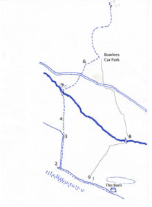
- Turn right from the barn and walk uphill to the Drumlins notice board [1]. From here the view down valley and behind the barn shows a group of low, rounded hills called Drumlins. These are a reminder that not so long ago the whole valley was occupied by a massive glacier. This glacier dumped and then shaped lots of boulder clay into the low, rounded hills you see before you.
- Continue up the hill. The road will bear right. Go straight on for a few metres and stop by the Holwick Scars information board [2]. Here you have great views of the crag called Holwick Scars. The crag is an exposure of the Whin Sill. The rock is dolerite which originated as molten rock which squeezed between the limestone, shale and sandstone beds – like jam in a sandwich. This rock is very hard which is why it resists erosion and creates many features of interest in the local area and beyond. It’s quarried locally and used as road stone.
- Now carry on around the bend, follow the road to the bottom to the cattle grid [3]. From here you can enjoy long vistas across the Teesdale valley, whose shape has been carved out by the glaciers that finally left the Dale about 18,000 years ago.
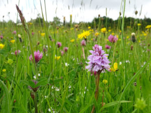
- From the cattle grid a faint track leads diagonally right across the meadow [4]. In summer the meadow provides a heady view of wildflowers including orchids. Teesdale has one of the largest areas of natural meadow in the country, which is why it is protected from modern farming methods. Needless to say, please keep to the path.
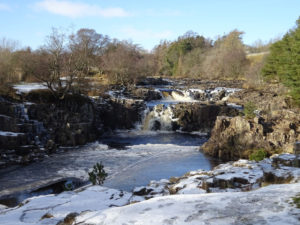
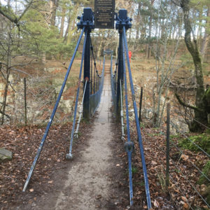
- Go over a couple of stiles and a small stone bridge over a stream. Follow the path for a couple of hundred metres and you will see Low Force ahead. To the left you could join the Pennine Way path which will take you on to High Force, but this is another walk. For this walk continue over Wynch Bridge and take in the view of the Falls. The bridge has an interesting history so don’t miss the information board [5]
- Once you have enjoyed these amazing views of the Falls continue your journey by following the path up the slope. There are steps to help you here. Go through the wall. The path takes you over a couple of fields to the road. Cross with care. To your right you will see the track that leads up to the Bowlees Visitor Centre [6].
Bowlees Visitor Centre is a great place to stop for refreshments, information and a comfort stop before your return journey back to The Barn. http://www.northpennines.org.uk/bowlees-visitor-centre/
For those of you who would prefer to drive to this point and visit the Centre and Gibson’s Cave [7], there is ample parking. Sat Nav reference is DL12 0XF
- At this point you can return home going back the way you came, or continue to Gibson’s Cave which is located behind Bowlees Visitor Centre .
- From Bowlees Visitor Centre follow the path to the car park. Turn left and follow the path by the stream. In a couple of hundred metres you will arrive at Summerhill Force and Gibson’s Cave.
Gibson’s Cave and its Force (Summerhill Force) is a breath taking sight which has a very interesting history. Find out more by following this link to Gibson’s Cave. https://www.gazettelive.co.uk/news/teesside-news/curious-outlaw-history-tees-beauty-15271483
- Return to The Barn either by reversing the route back to Bowlees, Low Force and up the hill into Holwick. Or from Bowlees car park go to the main road
- Cross over the road. In a short walk along the road towards Middleton take the signed footpath across the fields which takes you past a farm and woods to Scorberry Bridge over the River Tees. Before you cross the bridge take a look at the flat rock on the banks of the Tees. The limestone here is packed with fossils of marine life, best seen when the rock is wet. [8].
- Continue over the bridge to meet the Pennine Way. Turn right and then almost immediately over the stile follow the path diagonally to the right where you will see a gate. Pass through the gate then left across the fields. You will pass a barn on your left as you walk up the hill side. To your right are a number of dry stone walls. Some of these are very old, dating back to early settlements. They are characterised by large rounded boulders that were cleared from the fields and piled up into walls by the earliest farmers, others are more recent and are more organised and regular and made with quarried stone.
- Bear left at the top towards the School House and the stile on the road from The Barn.
Before you cross over the stile, where you are standing you will notice a lot of rubble, but when you look closely you will see a rectangular wall of stone and tufts of earth [9]. This marks the remains of an ancient settlement dating back at least to the Middle Ages and almost certainly occupying the site of a Neolithic settlement. You’ll see further evidence of ancient dry stone walling here too.
This settlement is one of many in this locality that are of great archaeological interest. Find out more by visiting this link to Altogether Archaeology https://altogetherarchaeology.org/
Turn left and walk down the road back to The Barn.
If you fancy eggs for breakfast I can highly recommend that you pick up some of Jenny’s free range eggs on your way back down the hill.
WALK 2 High Force Approx 7 km 2 hours
WALK 2 THE BARN TO HIGH FORCE
About 7km. 2 hours.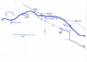
- Follow Walk one to Low Force (point 5). In other words, go up the hill and follow the road to its end at the cattle grid, then cross the fields to Low Force.
- At Wynch Bridge turn left past the sheep [6] and follow the Pennine Way path alongside the river on the Holwick side. In summer the banks of the river are clothed in a variety of flora whilst the fields to the left are covered with species rich meadow.
- After just over a kilometre there is a meeting of paths and a bridge across the river [7].
- At this point there is an opportunity for a diversion to a well-known country pub ‘The High Force Hotel’, which is less than one kilometre away. If you decide to visit, cross the bridge, ignore the main path that bares right and up to the road, instead turn left and walk the path alongside the river. This bares right gradually across the field to a stile in the wall, then climbs up through the woods (some steps here). The path exits to the road almost opposite the Hotel [8].It is possible to drive here from The Barn but there are fees for using the large car park.Once refreshed you could walk to High Force directly from the Hotel but there is a fee and the views are not the best.A better alternative is to reverse your route down the path through the woods to the bridge.
- After crossing the bridge turn right and follow the Pennine Way path up the hill still following the river upstream. After about 100m you will come to a gate and an information board. Next to the board is a foot-wash which you should use on the way back [9]. You will see that you are surrounded by dwarf juniper. This is one of the most extensive areas of this rare plant in the whole of the UK but it needs protection from a pest, hence the fencing and foot-wash.
Carry on from this point weaving through the juniper for about one km. You will soon start to hear the roar of the waterfall before you can see it. There are a couple of viewing points on short side trails which are favourites with photographers but take great care because they are on the edge of vertical cliff faces. Staying with the path brings you to the top of the waterfall – England’s biggest -where the views are truly spectacular [10]. A good spot for a picnic and photos.
Extension to Blea Beck Force
If you have the time and energy a short extension takes you a little further upstream to this beautiful but rarely visited waterfall.
Continue upstream on the Pennine way (there is another foot-wash here which you should use as you are leaving the protected area). After less than one km there is a small footbridge over a stream. There is a large working quarry on your right over the river and to your left Blea Beck Force [11].
Return to High Force waterfall and the Information board and foot-wash passed on the outward journey. Use the foot-wash again.
CIRCULAR EXTENSION ALTERNATIVE
At this point you could simply return along the river to Low Force and on homeward to The Barn as per the outward journey but there is a more satisfying return from this point that makes it a more circular walk.
From the foot-wash go through the gate but do not turn left and down the hill but follow the path straight ahead past Holwick Head house.
Follow this obvious path through fields, Heald House farm (barking dogs!!), more fields and then gradually uphill past a wood. Good views of the valley down to the Tees from here. You may be able to spot remains of ancient settlements in the fields.
Stay on the track passing a farm and a junction to Holwick House – Lord Strathmore’s hunting lodge – to the cattle grid and the road back to The Barn.
WALK 3 The Barn to Sheep Stile Approx 1.5km 20 mins
THE BARN TO THE SHEEP STILE
1.5km. 20 minutes. 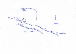
This walk is great if you would like a short walk but would still like great views and points of local interest on the way.
- Turn right from The Barn and walk up the road passing the Drumlins information board and the ancient settlements in the fields. Walk on to the bend in the road and the Holwick Scars information board [1].
- From here carry on up the track passing through a gate with a cottage on the left.
- There are several cottages in Holwick that are built using the local Whinstone. This very hard rock is difficult to shape so you will only find it used as a building stone in Holwick because the source (the crags) was so handy.
- Keep going uphill ignoring a track to the right which goes to another cottage. The path climbs gradually along the side of a small but steep little valley. You will see lots of rabbits here! Take a moment to look closely at the dolerite Whinstone that is exposed on the right of the path [2]. You may make out that the rock is cracked into vertical columns that are roughly hexagonal. This pattern of cracking occurred as the dolerite, which was once molten rock, cooled and contracted.
- Walk on uphill past the small signpost to a gate and stile, which is carved in stone into a pair of sheep. There is a good photo opportunity here [3]. To the right you can see the majestic Holwick Hall. This is Earle Strathmore’s hunting lodge. The Strathmore estate covers much of the land south of the river. The land north of the river is the Raby estate. In good years this is one of the best grouse moors in the UK.
- Although the bridleway continues up the gravel path this short walk ends here. For some great views of Teesdale you could walk a few meters up the grassy slope to the top of the hill above the path [4].
From here return to The Barn via the outward journey. You could collect some delicious free range eggs for breakfast from Jenny’s hens, which are kept in a box outside of her house.
WALK 4 The Barn to Middleton in Teesdale Approx 8km 4 hours circular
The Barn to Middleton in Teesdale
A lovely walk along the Pennine Way by the River Tees.

- From The Barn turn right up the hill to the Schoolhouse and footpath sign to the right [1].
- Follow the path down the hill, passing a barn, to a stile in the fence at the bottom.
- Turn right on the Pennine Way path.
- After about 100m pass Scorberry Bridge. Take a short diversion across the bridge to see the fossils in the bare rock on the opposite side [2].
- Return across the bridge to the Pennine Way and follow this all the way to Middleton in Teesdale. The path has some ups and downs but passes through glorious meadows and woodland and ends at the Cattle Mart.
- Turn left on the road to cross the bridge into Middleton [3]
Before boundary changes in the 1970’s the river marked the border between Yorkshire and Durham. Now both sides of the river are in County Durham.
There are lots of opportunities to browse and take refreshments in Middleton [4].
One option for the return journey is to simply reverse the outward route. The path is the same but the views are entirely different.
To make it a more circular route involves walking up Holwick road.
From Middleton walk down the road to the bridge, past the Mart and up the other side to the junction at the Gatehouse [5].
Take the minor road to the right, signposted Holwick. Follow this for about 3km to The Barn. This as a pleasant walk but it is along a road. It passes old quarries in the Whin Sill, very old woodland at Park End Wood and the remains of an ancient settlement at Unthank.
This road is not busy but does get some traffic so take due care.